Ireland: Two-Week Road Trip Around the Emerald Isle
Ireland had been on my travel list for years. After spending two weeks in Italy, we finally made our way to Dublin to kick off a two-week road trip around the Emerald Isle. Here’s what we learned about exploring Ireland by car—logistics, highlights, and the places we visited.
Understanding Ireland: A Brief Historical Context
Before diving into our travel experiences, it’s worth understanding the historical backdrop that shaped modern Ireland. The island’s complex past is evident everywhere you travel, from ancient stone circles to political murals in Belfast.
Today, the island of Ireland is divided into two separate political entities: the Republic of Ireland (also called simply “Ireland”), which is an independent nation and EU member state covering about 80% of the island, and Northern Ireland, which remains part of the United Kingdom alongside England, Scotland, and Wales. This division, which we’ll explore in the historical context below, means you’ll technically be visiting two different countries during your trip, though the border crossing is seamless and largely invisible to travelers. More on the differences between the two in the FAQ section.
Ancient Ireland and Celtic Heritage
Ireland’s recorded history stretches back thousands of years. The island was inhabited by various Celtic tribes who established a rich culture of art, mythology, and law. These early Irish developed a sophisticated society with skilled metalworkers, storytellers, and scholars. You’ll encounter remnants of this ancient world throughout your travels—stone circles like the one we visited at Uragh, ring forts scattered across the countryside, and Celtic crosses in old graveyards. The Irish language (Gaeilge) and many cultural traditions trace their roots to this Celtic heritage.
Christianity arrived in the 5th century, traditionally credited to St. Patrick, and Ireland became known as the “Land of Saints and Scholars.” Irish monks preserved much of European learning during the Dark Ages and established monasteries across the continent. The famous Book of Kells, though now a tourist attraction in Dublin, represents this golden age of Irish scholarship and artistry.
English Conquest and Colonial Rule (12th Century - Early 20th Century)
The Anglo-Norman invasion of 1169 marked the beginning of English involvement in Irish affairs, though initially, the Norman settlers largely integrated with Gaelic Irish culture. Real control came later with the Tudor conquest in the 16th century, when English (and later British) rule was systematically imposed across the island.
The English implemented a series of oppressive policies designed to control the Irish population and consolidate British power. The Plantation of Ulster brought Protestant settlers from Scotland and England to Northern Ireland, fundamentally altering the region’s demographics. The Penal Laws restricted Irish Catholics from owning land, practicing their religion freely, or participating in politics. By the 18th century, a small Protestant minority owned most of the land while the Catholic majority lived in poverty as tenant farmers.
These centuries of colonial rule created deep social divisions and economic inequality that would have devastating consequences when the potato blight struck in the 1840s. The majority of the Irish population had been forced to depend on potatoes as their primary food source because they had been pushed off better land and into subsistence farming.
The Great Famine (1845-1852)
The Irish Potato Famine was certainly the most devastating event in Irish history. When a potato disease destroyed the crop that fed much of the population, approximately one million people died and another million emigrated, reducing Ireland’s population by 20-25%. The British government’s inadequate response deepened resentment toward English rule. You’ll see famine memorials and museums throughout Ireland, and the event fundamentally changed Irish society, spurring massive emigration to America and other countries. It is important to note that although the food shortage was only for a few years, its impact was far more long-lasting, as the demographic catastrophe of death and emigration decimated the young workforce, crippling the economy for decades. The collapse of the agricultural system and limited industrialization further hindered recovery, while the social trauma and political disempowerment created a cycle of poverty and weakness that persisted for over a century, preventing Ireland from recuperating due to the profound and enduring loss of people, economic capacity, and social cohesion.
The Path to Independence
Ireland’s struggle for independence from British rule culminated in the 1916 Easter Rising in Dublin, where Irish republicans proclaimed an independent Irish Republic. Though initially unsuccessful, it sparked a series of events leading to the Irish War of Independence (1919-1921). The conflict ended with the Government of Ireland Act 1920, which partitioned Ireland into two separate jurisdictions: Northern Ireland (remaining part of the United Kingdom) and what became the Irish Free State in 1922, later becoming the Republic of Ireland in 1949.
The Troubles (1960s-1998)
The partition created lasting tensions, particularly in Northern Ireland, where the Protestant unionist majority held political and economic power over the Catholic nationalist minority. This led to decades of conflict known as “The Troubles”—a period of political violence, bombings, and civil unrest. The conflict officially ended with the Good Friday Agreement in 1998, which established power-sharing arrangements and largely brought peace to the region. I perfectly remember growing up hearing in the news about all the bombings and issues happening in Northern Ireland.
Modern Ireland
Today, the Republic of Ireland is a prosperous EU member nation, while Northern Ireland remains part of the United Kingdom. Brexit has created new complexities, but the peace process remains largely intact. When traveling, you’ll cross the border between the Republic and Northern Ireland without even noticing—there are no checkpoints or visible barriers, a testament to how much progress has been made since the dark days of The Troubles.
Understanding this history adds depth to your travels, whether you’re walking through Dublin where the Easter Rising took place, visiting Derry’s murals that tell the story of The Troubles, or simply appreciating the peace and prosperity that allows visitors to freely explore this beautiful island.
Getting Around: The Logistics of Traveling in Ireland
Renting a Car
Before you book that rental car, here’s something most people don’t know: most travel credit cards don’t provide insurance coverage for cars rented in Ireland. This caught us off guard during planning, so make sure to check your card’s terms. You don’t necessarily need full insurance coverage, and Collision Damage Waiver (CDW) typically comes included with most bookings. We opted to reduce our maximum out-of-pocket expense to a lower amount rather than going for zero deductible, which kept costs reasonable while still providing peace of mind.
Driving on the Left
This wasn’t my first time driving on the left side of the road, and honestly, it was even easier this time around. I didn’t encounter any major issues, and the Irish drivers are remarkably considerate—a pleasant surprise that made the whole experience much more relaxed than expected. More on the whole driving experience in Ireland in the FAQ section.
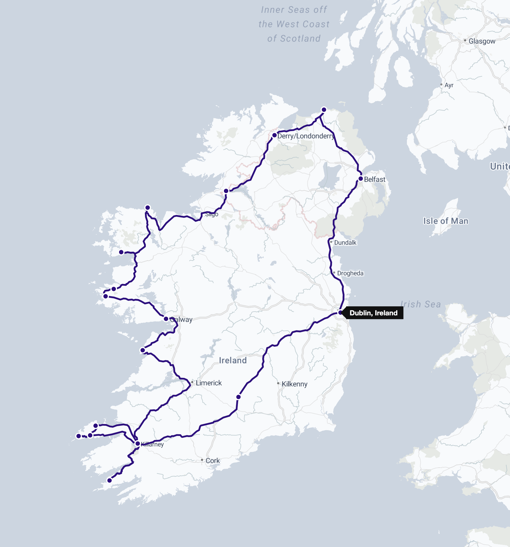
Our Two-Week Itinerary
Since we planned to tour much of the island, spending several days on the road was inevitable. We began with two nights in Dublin without a car, then picked up our rental at the airport and headed south to Killarney, stopping at the Rock of Cashel along the way. Killarney became our base for three nights, giving us time to explore both the Dingle and Beara Peninsulas on day trips.
From there, we spent three days driving up Ireland’s western coast, visiting the Cliffs of Moher, Galway, Kylemore Abbey, and Downpatrick Head, before crossing into Northern Ireland. We dedicated four nights there, exploring Londonderry (Derry), Giant’s Causeway, Dunluce Castle, and Belfast, before ending the trip with a final night near Dublin Airport ahead of our departure.
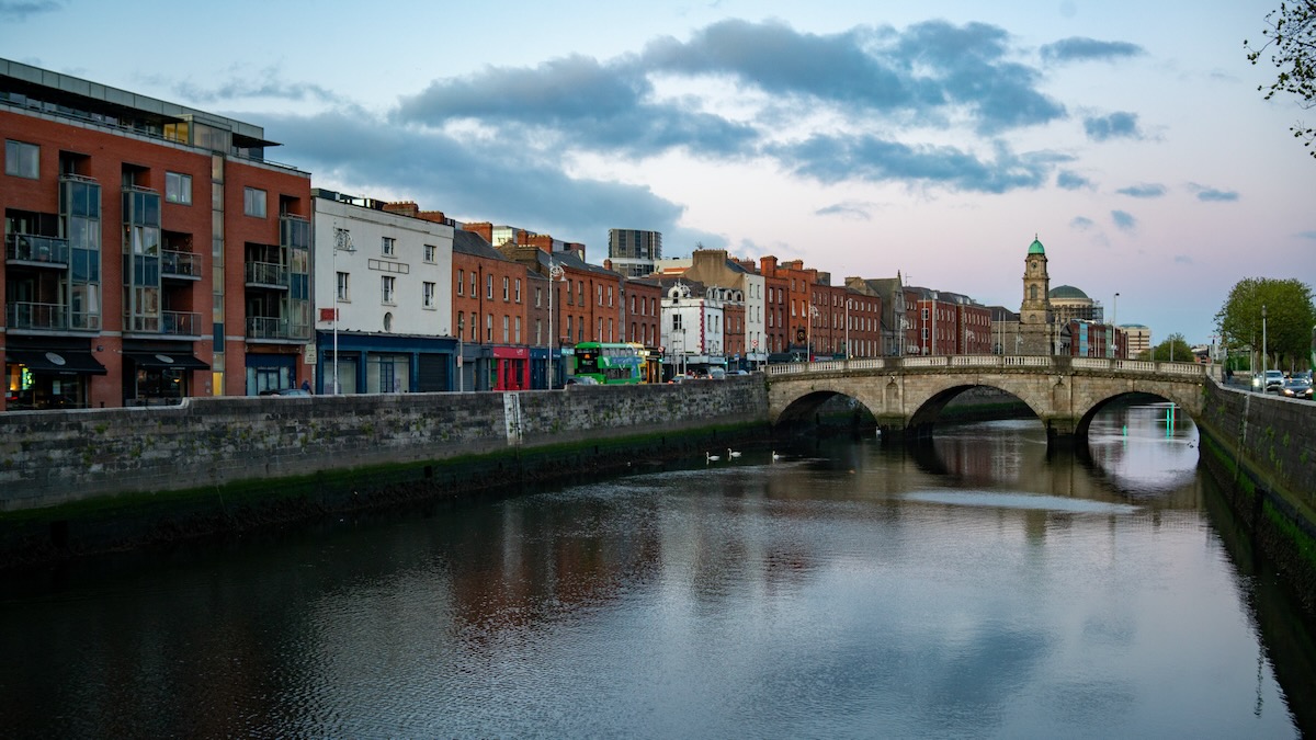
Dublin: Beyond the Tourist Traps
Dublin is undeniably touristy and, frankly, quite expensive. The city draws millions of visitors annually, largely due to its rich literary history, iconic pubs, and famous attractions. However, after some research, we realized that many of the most famous spots—the Book of Kells Experience, Guinness Storehouse tour, and even the Temple Bar area—felt more like tourist traps than authentic experiences.
Instead, we ventured to the Stoneybatter neighborhood, where we found pubs filled with locals rather than tourists. The difference was immediately apparent, and we had a much better time mingling with actual Dubliners. Pubs are central to Irish culture and social life—they’re not just places to drink, but community gathering spots where people of all ages come to socialize, share stories, and often enjoy traditional music. Going to a pub while in Ireland isn’t just recommended; it’s essential for understanding the local culture.
As for Guinness, it does taste excellent in Ireland, though I can’t definitively say it’s better than what you get in the US. The atmosphere of drinking it in its homeland certainly adds to the experience, though.
Exploring the Wild Atlantic Way
Killarney: The Perfect Base
We chose Killarney as our southwestern Ireland base, and it proved ideal for exploring the region. There are three main day trips from Killarney: the Ring of Kerry (the most popular), Dingle Peninsula (the most scenic), and Beara Peninsula (the least explored). We deliberately skipped the Ring of Kerry due to its reputation for tourist bus congestion and instead focused on the other two.
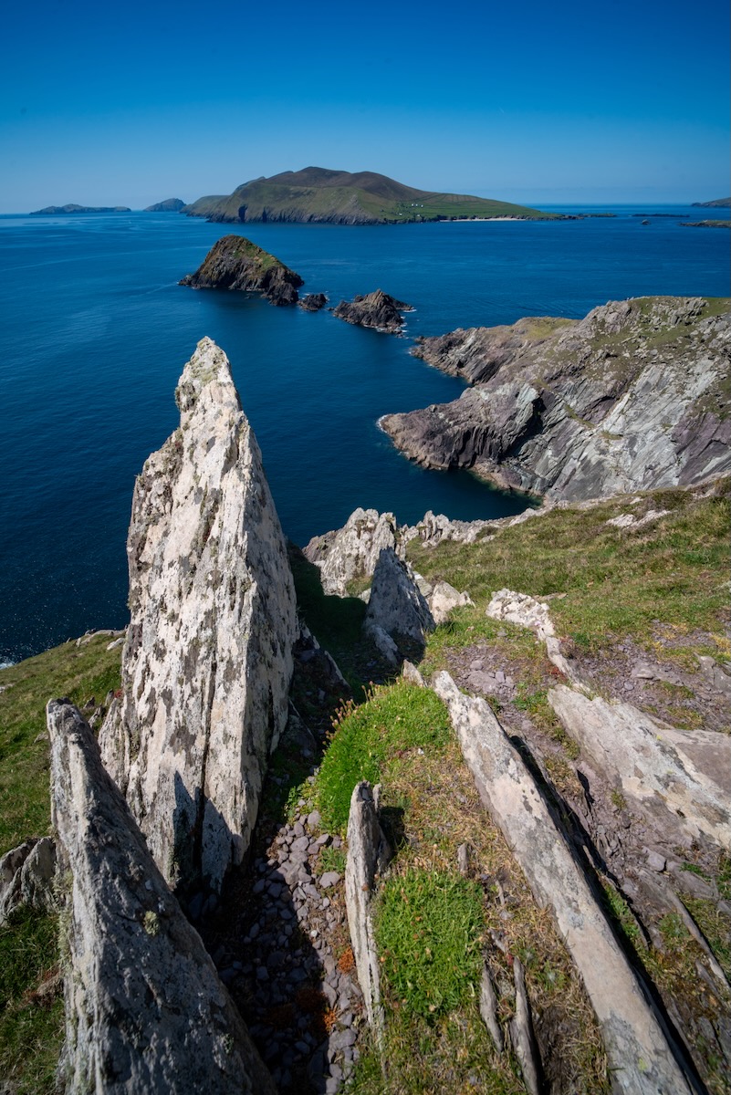
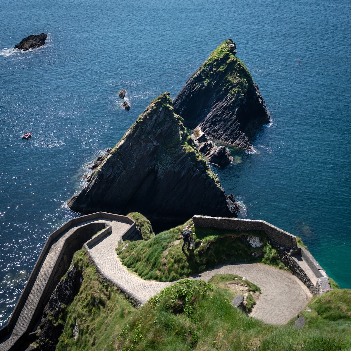
Dingle Peninsula: The Scenic Highlight
The Dingle Peninsula turned out to be the most scenic day trip of our entire journey and certainly a highlight of the trip. The combination of rugged coastline, traditional Irish culture, and stunning vistas made it unforgettable.
Key stops included:
- Conor Pass: Dramatic mountain views and winding roads
- Slea Head Drive: Spectacular coastal scenery with ancient stone structures. I managed to do some great photos there, and I thoroughly enjoyed it.
- Dunmore Head: Ireland’s westernmost point with breathtaking cliff views
- Dunquin Pier: A picturesque harbor with traditional currach boats
- Town of Dingle: Charming fishing town with excellent seafood and traditional music
Beara Peninsula: Off the Beaten Path
The Beara Peninsula offered a completely different experience—we encountered very few tourists, making it perfect for those seeking an off-the-beaten-track adventure. While beautiful, it felt more remote and less dramatically scenic than Dingle.
Notable stops included:
- Town of Kenmare: Colorful buildings and artisan shops
- Healy Pass: Mountain pass with panoramic views
- Town of Eyeries: One of Ireland’s most colorful villages
- Uragh Stone Circle: Ancient stone circle in a mountain setting
Overall, while both peninsulas have their merits, Dingle Peninsula certainly edges out Beara for sheer scenic beauty and cultural richness.
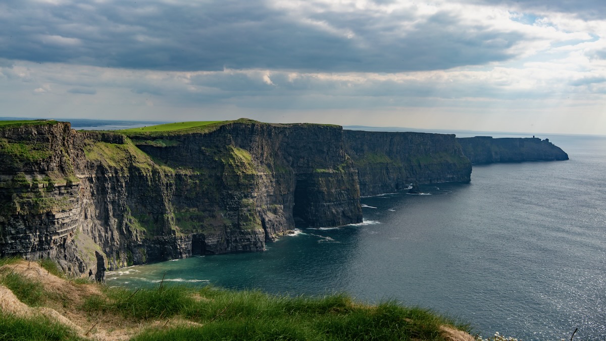
Cliffs of Moher: A Mixed Experience
The Cliffs of Moher are undoubtedly iconic, but our visit was somewhat disappointing. There are two main access points, but the coastal trail was closed during our visit. The protective fencing is positioned quite far from the cliff edge, which limits photo opportunities, and we unfortunately encountered overcast weather that wasn’t ideal for photography. While still worth seeing, manage your expectations—it’s not always the dramatic experience you see in photos. Overall, I would not highly recommend visiting Cliffs of Moher.
Drive to Northern Ireland: Hidden Gems
Our journey north included several memorable stops:
- Galway: Vibrant city with excellent traditional music scene, but we only visited it for a few hours.
- Sky Road: Scenic coastal drive with stunning Atlantic views, similar to those in Dingle Peninsula.
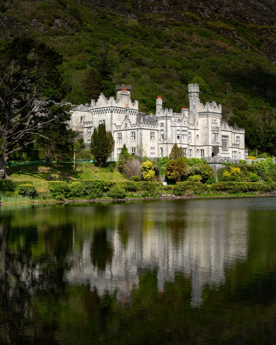
- Kylemore Abbey: Victorian castle and gardens in a lake setting. We didn’t go in, but the exterior view was gorgeous.
- Downpatrick Head: Dramatic sea stack and coastal views, which we actually really enjoyed, as there were no barriers, and we could get a good view.
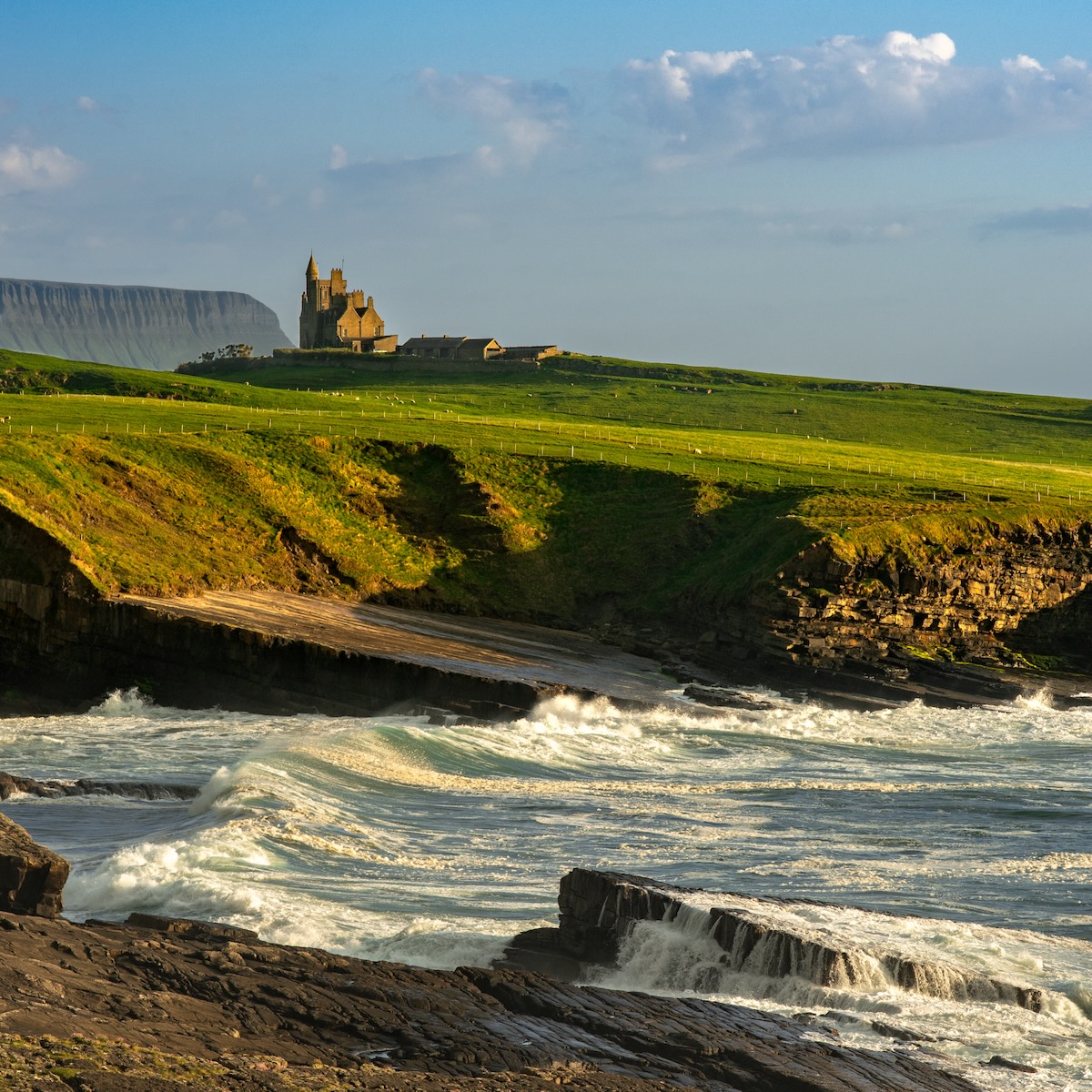
- Classiebawn Castle viewpoint: This was such a serendipitous find on Google Maps! On our way to Northern Ireland, we decided to stop for a quick snap, but we ended up waiting a couple of hours for the right light to photograph this castle from the beach, and the patience paid off with some fantastic shots!
Northern Ireland: Unexpected Highlights
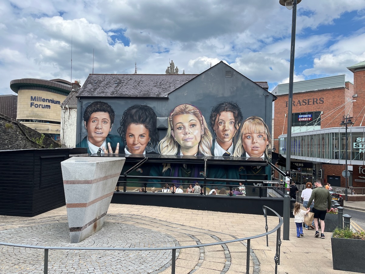
Derry/Londonderry: A Cultural Gem
We first learned about Derry from the brilliant TV show “Derry Girls” (seriously, watch it if you haven’t), and we knew we had to visit when planning our Northern Ireland leg. The city exceeded our expectations—the locals’ accents made us feel like we were living in the show, and striking up conversations with residents revealed their genuine warmth and friendliness.
Beaches: Ireland’s Surprise
Most people don’t think of Ireland as a beach destination, but it has some genuinely nice coastlines when the weather cooperates. One unique and slightly off-putting observation was locals driving their cars directly onto the beach (particularly at Benone Beach), which seemed both a bit dangerous and environmentally questionable. Despite this, our son loved playing in the sand, and we enjoyed the unexpected beach time.
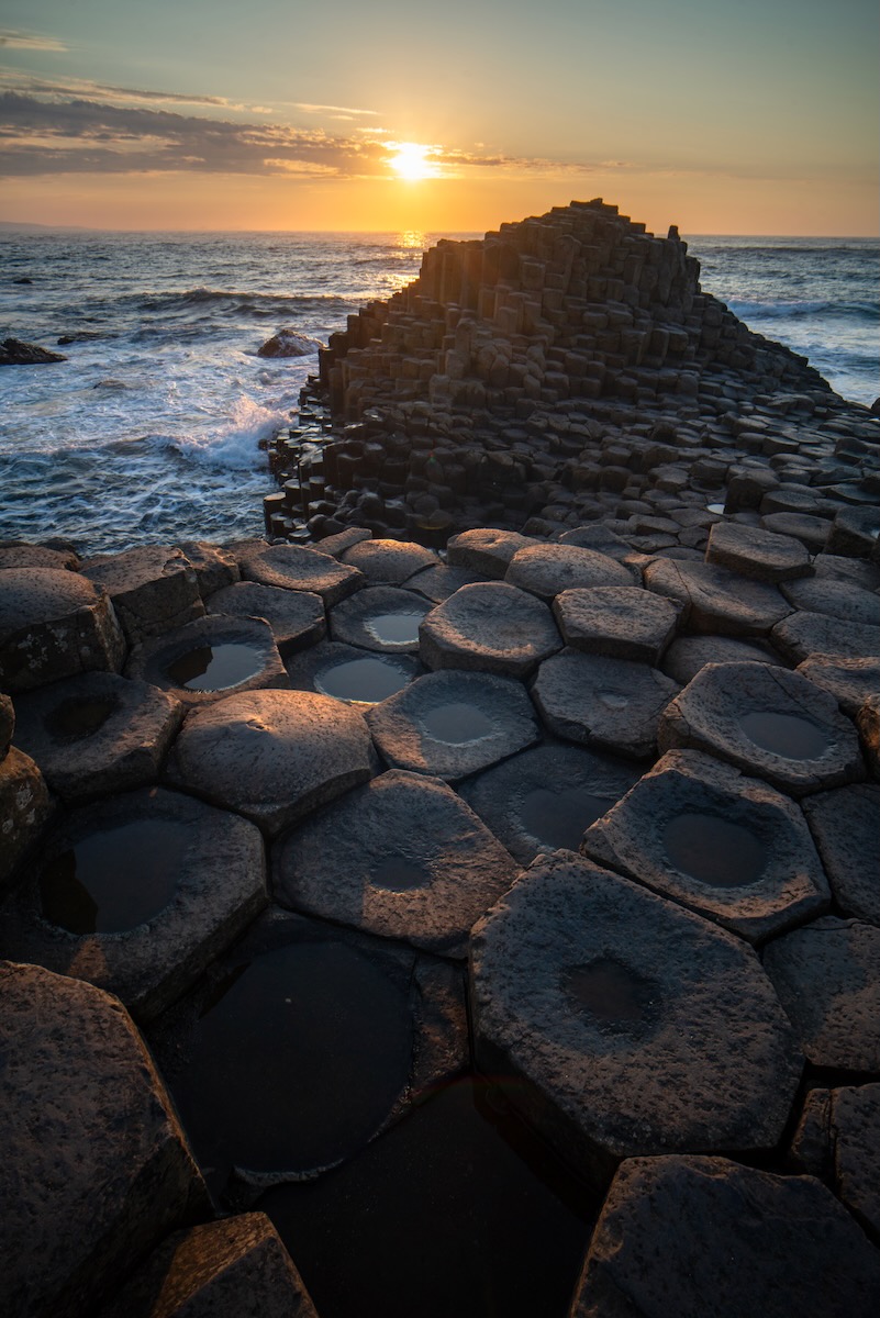
Giant’s Causeway: Nature’s Architecture
Giant’s Causeway is probably Northern Ireland’s most famous attraction, and for good reason. This UNESCO World Heritage site consists of about 40,000 interlocking basalt columns formed by ancient volcanic activity. The columns were created when molten lava cooled rapidly, causing it to contract and crack in hexagonal patterns—a geological process that took place around 50-60 million years ago.
As a photography enthusiast, I’d long wanted to visit this iconic location. However, the experience was somewhat underwhelming because it’s best photographed during specific sunset lighting conditions, which we didn’t encounter. The location also benefits from proper equipment like a good tripod and neutral density filters, which I didn’t have with me. Still, I was glad to try capturing this world-famous geological wonder.
Other Northern Ireland Highlights
Dunluce Castle sits dramatically on a cliff edge, though we didn’t tour the ruins themselves. Instead, I managed to photograph it from a nearby cliff. Unfortunately, you can no longer get closer to it, due to private land and fencing, which limits photo opportunities.
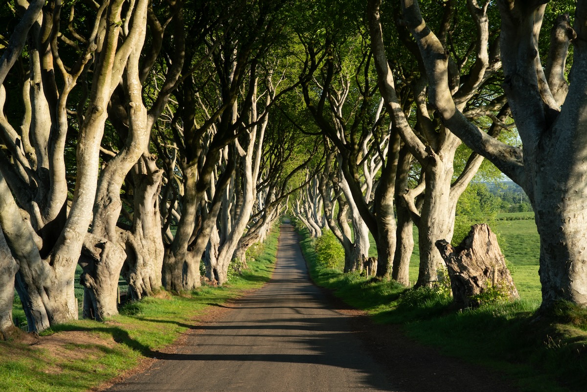
The Dark Hedges, a stunning avenue of beech trees, gained international fame as a filming location for Game of Thrones, where it portrayed the Kingsroad. The intertwined branches create a dramatic, tunnel-like canopy that’s both picturesque and mysterious. I arrived early morning before other visitors and captured the shot I’d envisioned.
We also took time to slow down after so many days on the road. Our Airbnb was on a working farm with incredibly kind and welcoming owners. We even got to bottle-feed some lambs, which was a delightful experience for our son and a nice reminder that travel is about more than just checking off tourist sites.
Final Thoughts
Ireland delivered on every front: stunning landscapes, rich culture, friendly people, and that charm that makes you understand why so many people fall in love with the Emerald Isle. Whether you’re drawn by the dramatic coastlines, the literary history, or simply the promise of a proper pint in a traditional pub, Ireland won’t disappoint.
We were incredibly fortunate with the weather during our early May visit. It only rained lightly for one day, and while we had a few cloudy days, the conditions were largely excellent. Even locals commented on how unusually good the weather was—apparently, we hit the jackpot with Ireland’s notoriously unpredictable climate.
FAQ
How challenging is driving in Ireland?
Left-hand driving was actually easier the second time around (first time being in Autralia and New Zealand in 2024). One helpful detail: Unlike Australia and New Zealand, the turn signal and windshield wiper stalks are in the same positions as US cars, which reduces confusion.
I did make one mistake at some point in the middle of our trip, driving on the right side for about a minute or so when no other cars were around, but then I realized something is off, and quickly adjusted! This was a stark reminder of how important it is to stay vigilant every time you get behind the wheel.
The roads are narrow and winding with surprisingly high speed limits, but there aren’t many pull-ins or rest stops. The good news is that Irish drivers are generally courteous and patient, which makes the experience much more pleasant than it could be.
What exactly is a tourist trap, and how can you spot them?
To me, a tourist trap is a place that’s overly famous and popular but doesn’t live up to the hype in person. These places often are worth a visit (though sometimes not), but they are either overpriced, and/or overly crowded that make them less appealing. Some places are very expensive and very crowded, but they are still worth a visit, e.g. Venice, or Paris, so I do not consider those “tourist traps”.
In Ireland, examples include the Guinness Storehouse (overpriced brewery tour), Temple Bar area (expensive drinks, touristy atmosphere), and parts of the Ring of Kerry (bus-clogged scenic route). The Book of Kells Experience, while historically significant, also fits this pattern with high admission fees and crowds.
Instead, I prefer to seek out places that locals actually go: neighborhood pubs, smaller towns, less famous but equally beautiful scenic routes, and attractions without massive parking lots full of tour buses.
What differences will I notice traveling between the Republic of Ireland and Northern Ireland?
While the border crossing is invisible and seamless, there are several practical differences you’ll encounter:
Currency: The Republic of Ireland uses the Euro (€), while Northern Ireland uses the British Pound Sterling (£).
Road signs: In the Republic, distances are shown in kilometers and speed limits in km/h, while Northern Ireland uses miles and mph. Road signs in the Republic are bilingual (English and Irish Gaelic), while Northern Ireland signs are English-only.
Phone service: Your mobile phone will switch between Irish and UK networks. EU roaming rules apply in the Republic of Ireland but not in Northern Ireland (post-Brexit), so check your phone plan’s UK roaming charges.
Accents and culture: While both regions are unmistakably Irish, you’ll notice significant differences in accents and some cultural references. Northern Ireland has stronger British influences in some areas, though Irish culture remains predominant.
Political symbols: You’ll see different flags, symbols, and murals, particularly in urban areas. The Republic flies the Irish tricolor, while Northern Ireland displays both Union Jacks and Irish flags depending on the community.
Despite these differences, the overall travel experience feels remarkably unified. The landscapes are equally stunning, the hospitality equally warm, and the cultural heritage deeply intertwined across both regions.
One minor issue we ran into was that our rental car from Dublin displayed speed in km/h, but in Northern Ireland, the speed limits are in mph. The car had a road sign recognition system that read speed limit signs and alerted us if we were over the limit. So, if the limit was 40 mph—about 65 km/h—the car would beep to tell us to slow down if we were going above 40 km/h! Thankfully, it didn’t beep continuously, but it did happen every time we passed a speed limit sign. Not a big deal, just a bit annoying.
Why is Ireland’s population smaller today than it was in the 19th century?
This is one of the most striking aspects of Irish history. In 1841, Ireland’s population peaked at about 8.2 million people. Today, the entire island has only around 7 million people (about 5 million in the Republic of Ireland and 1.9 million in Northern Ireland)—still below its pre-famine levels nearly 180 years later.
The Great Famine (1845-1852) was the primary catalyst for this demographic collapse. Approximately one million people died from starvation and disease, while another million emigrated during the famine years. But the emigration didn’t stop there—economic hardship and limited opportunities continued to drive people away for decades afterward.
Between 1851 and 1921, Ireland lost nearly half its population through emigration, with most people heading to America, Britain, Australia, and other English-speaking countries. This created a self-perpetuating cycle: as young people left, birth rates declined, and economic opportunities remained limited in many rural areas.
The scale of Irish emigration is staggering—an estimated 10 million people left Ireland between 1800 and 1921. Today, there are more people of Irish descent living outside Ireland than within it, with about 35 million Americans claiming Irish ancestry.
This history explains why you’ll find relatively few people in Ireland’s countryside compared to other European countries of similar size. Many of the stone cottages and ruins you’ll see scattered across the landscape are remnants of a much more populous rural Ireland.